Silte zone administration is among one of the 7 zones and 3 special Woredas that forms central Ethiopia Region covering an area of 2700.04 Square Kilometer. Astronomically, it is roughly in between 7043'-8010' N latitude and 37086' -38053' E longitude. It is bordered with in the South Hadiya Zone, in the north East Gurage Zone, and in the west Gurage Zone, in the north east Mareko special wereda, in the east Oromia Region and in south-east Halaba Zone.
It was established soon after referendum that had been taken by SELTIE nationality in March 23 1993 E.C. Zonal Addministration Contains 10 WOREDAS and 5 town administrations namely, Dalocha, Silti, Misrak Silti, Lanfuro, Mito, Sankura, West Azernet Berbere, East Azernet Berbere, Hulbarag, Woreabe Town Administration, Tora Town Administration, Kibet Town Administration, Dalocha Town Administration, Alemgebeya Town Administration. Zonal capital town is Worabe located on the main road from Addis Ababa to Hossana just 172KM apart from Addis Ababa. According to the 2007 G.C Population and Housing Census of Ethiopia the Population of the zone in 2015 E.C were about 1,280,222 where 48.90% Male and 51.10% female concerning the settlement 78.07% and 21.93% of the population lives in rural and urban areas respectively. 99% of the Population is Muslim. Seltie is one of the central zones of the region with large plain land, mountainous area, plateaus. Regarding to the climate of the zone it has three different agro-climatic conditions, high land (DEGA and WURCH) and (WEYNA-DEGA). They are consisting 1.64%, 24.6% and 73.76% respectively. The average temperature ranges from 12-26CO and the average annual rainfall ranges from 780-1818mm. above 80% of the population engaged in agriculture. According to Zonal sector and Woredas reports of 2015 E.C there are 36 urban and 200 rural kebeles in the zone.
Climate is a long period average weather condition of a defined geographical area. It is determined by altitude, latitude, prevailing winds, cloud cover, pressure and wind belts. Altitude is by far determinant factor for the spatial variation of weather and climate. Among the elements of Weather and Climate, temperature and rainfall are important elements in determining the pattern Of population settlement, the range of crops and vegetation that can be grown, soil formation Processes and biodiversity and agro ecology of a given area.
The amount, duration and intensity of rainfall in this zone are decreases from west and northwest to south-eastwards. The main dry season is shorter in southern Ethiopia conversely the main rain season is larger in south west and in south. The past three decades rainfall data show that the lowest annual rainfall is 801mm and the 3 are mentioned highest Annual rainfall is 1200 mm. Relying on the reliability of rainfall for crop Production and duration of growing periods, the three seasonal patterns of rainfall in this zone experienced BEGA (Dec., Jan. Feb.). Provide rain for limited part of the region, BELG (little rain season) (March, April) the amount of rainfall received is relatively lower than the KEREMT Rainfall that occurred in June, July, August. However, in each of the seasons the rain may Begin earlier/later and lasts before the usual time. This has impact on growing period and reliability of rainfall.
Temperature is the quantity that tells us how hot or cold something is relative to some set standard Moisture content and the humidity of the atmosphere. The mean annual temperature of SELTIE zone is 10.1.However, the temperature is generally high with little variations among seasons. The Meteorological data of 2010 E.C. indicates that the mean annual maximum temperature of this zone is 22.5 Co& 11Co in the highlands of Siltie zone.
SILTIE zone has a very diverse agro-ecological conditions ranging from hot arid and semi-arid climate (KEFIL WURCH, DEGA & WOYNA DEGA type). In the southern most parts such as (DEGA and KEFIL-WURCH) type in the high lands of the North and Northwest. Most part of the zone, about 73.76% lies under WEYNA DEGA type of agro-ecology. Meanwhile, DEGA and KEFIL-WURCH climate condition consists 24.6%, 1.64% respectively. The varied agro climatic conditions of SELTIE zone endowed it with the production of different commercial and food crops.
The relief of SELTIE zone is generally characterized by highly dissected rugged highlands and undulating lowlands in southern part. SELTIE zone altitude ranging from 1500 to 3700 masl (meter above sea level) and the highland of MUGO is 3280 and Enslas Chekul 3700 masl respectively.
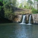
Siltie zone is endowed with abundant water resources. The nature & orientation of the relief features resulted in the formation of numerous drainage systems namely: Dijo, Furfuro, Konkaye, Kalid, Weyra, Garore, and Bobodo, Zywete & etc. Those drainage systems are providing benefits for the developments of fishery and other related purposes. On top of that the lakes and the lower parts of the rivers are using as the habitats for the great variety of fish, crocodile and birds.
Although it has not been fully surveyed and studied, significant area of mineral potentials found in Siltie zone. Studies of the Ethiopian Institute of Geological Survey (EIGS) reveal that the existing of many mineral resources is largely found in association with other mineral types in Siltie Zonal administration. The study also identified that the Zone has potentials of different types of minerals like Potash, coal (lignite), Diatomite, Clay, Salt, Dimension stones, and Construction materials. In addition to this, the Ethiopian Institute of Geology Surveys (EIGS) discloses the availability of GO -thermal energy in border line of Lanfuro and Dalocha woreda and as well Ensilas chekul moutains in Alicho weriro Wereda.
According to Seltie Zone Educational department annual statistical report, the number of schools at all educational level has been increasing each year. For instance, in 2014 and 2015 E.C the number Of KGS School (Including O class) reached to 720 and 725 respectively, with an average growth rate of one percent per annum for the last five years and all the Kindergartun schools are under taken by non-government organizations.
The zonal average growth rate of enrollment in Pre-primary schools has been about 30 percentage points in the last five years. The number of children enrolled in 2015 E.C. has increased tremendously as a result of the opening of ‘O class’ and child-to-child programs.
Access to ECCE education has showed rapid progress in 2015 E.C. Accordingly, the zonal GE reached about male 121,155 Female 116,439 Total 237,614 and the gender Parity index 0.91. This remarkable improvement is particularly due to the launching of ‘zero classes and child to child programs, mainly in government schools.
The health status is one of the most important socio-economic development indicators in some country. Hence exerting maximum effort and commitment to health sector development is very crucial. In relation to this, starting from issuance of new health policy of the nation, the zonal government gave due attention for the development of health sector to improve health of the zonal population. The ultimate goal of health sector development program is to improve the health status of the zonal people through provision of adequate and optimum quality of encouraging prevention, basic curative and rehabilitative health service to all segments of the population. As a result the health service coverage has shown encouraging increment in various health development packages.
In the budget year of 2015 E.C, a lot of activities have been done in the area of disease Prevention and improving the health of the community, implementing family health Care and controlling the transmitted diseases in each household level.
Regarding institutions, in 2015 E.C. some additional newly constructed institutions have started giving services; In general there are 01 Comprehensive Specialized Hospital, 03 Primary Hospitals, 36 Health Center & 181 Health Posts available in the zone.
In 2015 EFY 2,187 health professionals are engaged in the health sector, and among them 115 are physicians,766 are nurses (all types) 465 all health extension workers and other health professionals 241. Detail information about health professional Regarding to population-professional ratio of the zone is concerned, The service coverage of the zonal fact on health professional population ratio recorded as one physician serves 10,137 which indicates huge gap as per MOH standard 1:10,000 while in case of nurses one nurse serves 1,522 people revealing more than enough as per ministry of health standard which is 1: 2500 one health extension worker serves 2,501 on average.
As the 2015 E.C zonal Health department shows, the family planning service reached to 209,101 mothers.
Although there is a remarkable progress in reproductive health, a lot is expected to be done on the reproductive health care areas to achieve the target of MOH standard need 100%.
Agriculture is still the single most important Sector of country economy. Particularly agriculture performance is critical to meet food security objectives, foreign exchange requirements and basic needs, and to increase employment opportunities.
The land holding of peasants approximately 65% of housholdes have less than one hectar per household. A diversified cropping system and cropping pattern is practiced in the zone, based on the Agro-ecological characterized by altitude and climatic condition as well as soil type.
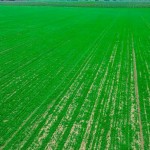
Farmer in the zone mainly uses systems of multiple cropping to maximize production per unit area. Now adays, farmer’s practices mechanized farming. The most common system in double cropping, inter-cropping relay cropping and rotation Maize, Teff & Enset (false banana), potatos, wheat, barely, pulses, fruits and vegetables are major crops, grown in the zone. Subsistence agriculture plays predominant role in food production. Food crop production of the zone was estimated 63,511,177 quintals in 2014/15 the area covered to produce the above amount was 160,445 Hectares.
To improve the economic and social well-being of the zone the zonal government has intensively involved in various development activities to realize the growth and transformation plan. Hence, still agriculture sector is believed to be the major economic activity. To achieve the objectives planned in the zonal government gave due attention to increase agriculture production and productivity. There is a remarkable variation of production of major food crops woredas. for instance, Silti, Lanfuro , Dalocha ,Hulbarag and Mito produced high amount of maize, production such as 218,688 quintals from 4,556 hectare. 218,721 quintals from 4,357 hectare. 114,550 quintal also from 3,950 hectare. Respectively and Hulbarag 122,670 quintals from 2,726 hectare and Mito 117,312 quintals from 2,444 hectare. Based on zonal rural development and poverty reduction strategy, there are a large number of Development Agenets (DA) have been trained and assigned in peasant association to produce promote improved agricultural produce.
Irrigation is one of the strategies of the zone to promote agricultural production. There are a number of water bodies, which have vital importance for irrigation development, fishery production, energy development and other social-economic uses, There are perennial and seasonal rivers in the zone having different volume, length and potential major rivers such as dijo, kalid, konqeya, weyra, garore, lebo, murtute etc… and a number of springs and waterfalls are found in this zone.
Livestock population has been estimated out of which cattle accounted to 1730798, sheep accounted to 711289, goats at accounted to 528726, poultry 4308304
Urbanization in the zonal is a recent phenomenon which is expanded due to historical and socioeconomic factors. By creating zonal urban centers and conducting study on public residential areas, the regional government has implemented conduciv urban development policy that resulted developed urban centers as a development growth poles. The numbers of towns in the zone increased and reached 30 in 2015 E.C.
According to definitions of CSA, areas having a population size more than 2000 and over 75% of its adult population engaged in non-agriculture activities are known to be towns. But for administrative purposes there are also towns with a population of less than 2000. According to central statistical agency 2007 census result, the projected urban populations for 2015 E.C. estimated at 286,387 which are 22.4% of the zone population.
The principal forms of transport within the zone comprise road vehicles, pack animals, and pedestrian traffic. Besides, there is very limited air service and the no water transport. Land transport particularly, road basically plays vital role in making easy communications, transporting freights and passengers. But, efforts made to improve transportation accessibility of the road transports within the zone. Still found to be medium developed and under maintained resulting in considerable isolation of large areas especially towards the east and west of the zone.
To address this problem, currently the government gave due attention and as a result a number of roads are under construction in the zone.
At the end of 2015 E.C. the zone has a total of road length 2424.33km. Out of which 495.22Km is gravel and 1929.11km dry weather. The road density shows 30.5% of constructed road in km per 1000 square km in a given area/zone. At zonal level data shows there is a slight improvement compared to previous year. At woreda level silti and lanfuro woreda have the highest density.
Telephone service is one of the most communication tools for social, economic, educational, business and investment activities. The quantity and quality of telephone service in the zone is increasing from year to year. Regarding fixed line, in the year 2015 E.C. about 26 towns or centres have acquired telephone service.
Electric power distribution substation newly constracted in 2015. Electricity is one of the modern sources of energy used as a source of Power in industries and for residents it is used as a fuel replacing Wood and cow dung. The zonal distribution of electric service expanded through both /ICS/ inters- connected system and (SCS) sub connected system. Electrification in seltie zone until 2015 E.C. 113 kebeles have got electric service through the system.
For more and detailed information please download the file below
Silte_Silte zone data.pdfDownload our app 👇